|
|
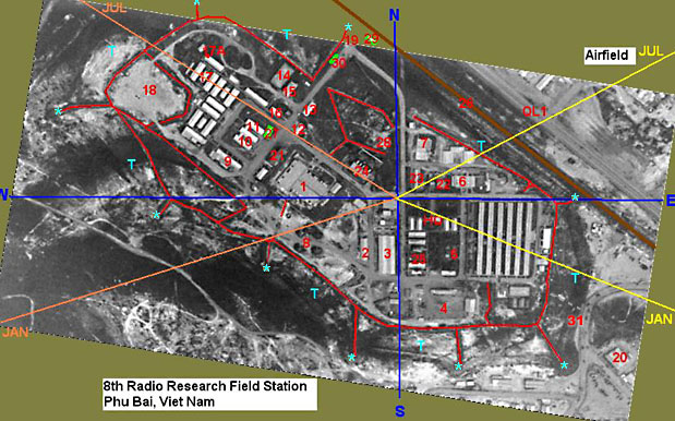
Red lines - Trench line. Blue I have numbered building/areas on the photo with what I remember them to be. — Email: WHHAWKINS@aol.com |
|
|
1. Operations Building 2. BOQ 3. Supply Warehouse 4. Motor Pool 5. EM Club 6. Mess Hall 7. Swimming Pool 8. Mortar Pits 9. Officers Club 10. PX 11. Library 12. MP Station 1968-1969 13. Vietnamese Shops 1968-1969, MP Station 1971-1972 (Don't know the actual year it moved) 14. Basketball court 15. Theater. Destroyed by a Typhoon 16. MARS Station right end of building. HQ Co., Orderly Room left end of building. 17. MP Hooch Area. 17a. My room, first room on the left. (NW Corner). |
18. Ball Field / Helicopter pad. 19. Main Gate (most of the time the only gate) 20. Phu Bai Area PX. 21. Fire Station 22. Water purification plant 23. VOQ 24. Generator's 25. Chapel 26. Railroad tracks 27. Military Police - TOC 28. Snack Bar 29. Covered Area used by the Vietnamese workers. 30. This is where the Vietnamese workers check in/out. Also on a random basis they were searched on entering and leaving. Found one worker with a drawing of the base, on cardboard from around the beer/soda pallets. He had the Clubs, Mess hall, Operations, and Theater all paced off. 31. Back Gate
|